
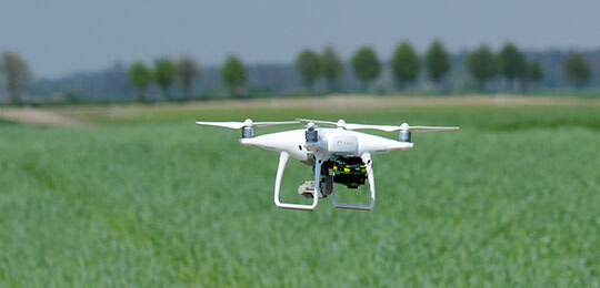
Unmanned Aerial Vehicles (UAV)
The application and utilization of UAV surveying and drone mapping services have increased dramatically over the years. Apex Geomatics Construction Surveyors Ltd. employs experienced, Transport Canada–certified UAV pilots who provide rapid, cost-effective acquisition of high-resolution aerial imagery and topographic information for precise spatial analysis.
Our UAV mapping and drone surveying solutions support all stages of construction and infrastructure development. Whether you need aerial surveying for design, quality control, or volume calculations, Apex delivers dependable data that integrates seamlessly with traditional surveying workflows.
With advanced drone surveying and mapping capabilities, we help clients access accurate site intelligence faster and more safely. As a trusted drone survey company in Western Canada, Apex provides reliable results for every project – from drone survey in Calgary to drone survey in Edmonton – ensuring exceptional accuracy, safety, and value on every site.
Services include, but are not limited to:
|
|
What are the Benefits of Drone Surveying and Mapping?
Drone surveying and mapping reduce time on site, improve safety, and deliver highly detailed spatial data. Apex provides drone mapping services that integrate with your workflow to support volume tracking, inspections, and more.
How Accurate is Drone Surveying Compared to Traditional Methods?
When done by certified professionals, drone surveying achieves centimeter-level accuracy. Apex combines UAV mapping with ground control and survey-grade equipment to ensure precise, consistent results across all job types.
What Industries Benefit Most from UAV Mapping?
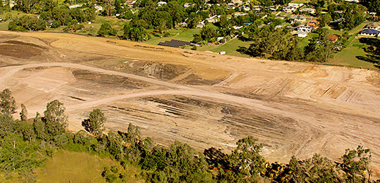
UAV mapping is widely used in construction, mining, energy, and infrastructure. Apex’s drone mapping services provide actionable insights for site planning, volume analysis, and progress tracking across multiple sectors.
When Should Aerial Surveying Be Used on a Project?
Aerial surveying is useful at multiple stages of a project, including planning, construction monitoring, and final documentation. It allows teams to quickly capture accurate site data and track progress throughout the project lifecycle.
How Fast Can Aerial Surveying Be Completed?
Aerial surveying can collect large amounts of site data much faster than traditional ground surveying methods. A drone can survey extensive areas in a short time, allowing teams to receive processed mapping data quickly.
Discover our Featured Services
Information gathered compliments other geospatial and survey data acquisition seamlessly. UAVs quickly advancing technology, safety and versatility, is lending itself well to usage in a variety of new ways within all industries that we service.

Highly accurate and detailed layout, collecting as-built data and document turnover. Using a combination of the newest equipment and technology, we help transform your paper plans into reality.
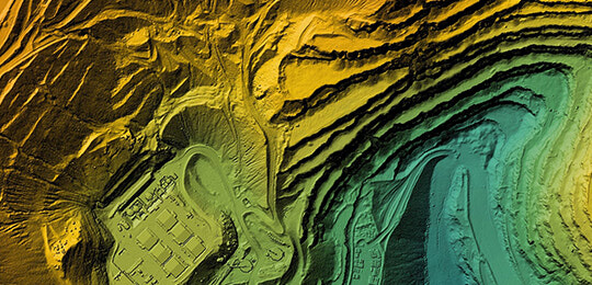
Transforming reality into a digital twin has never been easier. Using only the best 3D scanning equipment, we are able to capture anything the eye can see and turn it into a digital model and point cloud.
Whether looking to acquire a real property report, design a subdivision, plan a commercial build or stake a utility corridor, our diverse professionals offer comprehensive land surveying services.

Using the latest technology and procedures to ensure your work area is accurately marked and detailed mapping provided. Taking precautionary measures and preventing underground facilities during any ground disturbance cannot be understated.
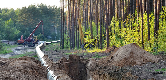
Our experienced team has the ability to assist with any pipeline scope. Apex has acquired years of experience supporting high-profile pipeline construction and maintenance projects from Saskatchewan to the coast of British Columbia.
Head Office
Apex Geomatics Construction Surveyors Ltd.
#132, 2181 Premier Way
Sherwood Park, AB
T8H 2V1
(587) 341-2375